| Deepwater Horizon oil spill | |
|---|---|
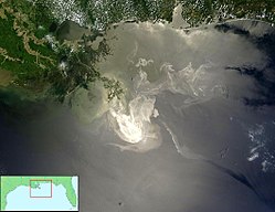
 The oil slick as seen from space by NASA's Terrasatellite on May 24, 2010. | |
| Location | Gulf of Mexico near Mississippi River Delta, United States |
| Coordinates | 28.736628°N 88.365997°W |
| Date | Spill date: 20 April – 15 July 2010 Well officially sealed: 19 September 2010 |
| Cause | |
| Cause | Wellhead blowout |
| Casualties | 13 dead (11 killed on Deepwater Horizon, 2 additional oil-related deaths)[1][2] 17 injured |
| Operator | Transocean under contract forBP[3] |
| Spill characteristics | |
| Volume | up to 4,900,000 barrels(206,000,000 US gallons; 779,000 cubic meters)[4] |
| Area | 2,500 to 68,000 sq mi (6,500 to 180,000 km2)[5] |
The Deepwater Horizon oil spill (also referred to as the BP oil spill, the Gulf of Mexico oil spill, the BP oil disaster or the Macondo blowout)[6][7][8] is an oil spill in the Gulf of Mexico which flowed for three months in 2010. The impact of the spill still continues even after the well was capped. It is the largest accidental marine oil spill in the history of the petroleum industry.[9][10][11] The spill stemmed from a sea-floor oil gusher that resulted from the April 20, 2010 Deepwater Horizon explosion. The explosion killed 11 men working on the platform and injured 17 others.[12] On July 15, the leak was stopped by capping the gushingwellhead,[13] after it had released about 4.9 million barrels (780×103 m3), or 205.8 million gallons of crude oil.[4] It was estimated that 53,000 barrels per day (8,400 m3/d) were escaping from the well just before it was capped.[11] It is believed that the daily flow rate diminished over time, starting at about 62,000 barrels per day (9,900 m3/d) and decreasing as the reservoir of hydrocarbons feeding the gusher was gradually depleted.[11] On September 19, the relief well process was successfully completed and the federal government declared the well "effectively dead".[14]
The spill continues to cause extensive damage to marine and wildlife habitats as well as the Gulf's fishing and tourism industries.[15][16] In late November 2010, 4,200 square miles (11,000 km2) of the Gulf were re-closed to shrimping after tar balls were found in shrimpers' nets.[17] The total amount of Louisiana shoreline impacted by oil grew from 287 in July to 320 miles (510 km) in late November.[18] In January 2011, eight months after the explosion, an oil spill commissioner reported that tar balls continue to wash up, oil sheen trails are seen in the wake of fishing boats, wetlands marsh grass remains fouled and dying, and that crude oil lies offshore in deep water and in fine silts and sands onshore.[19]
Skimmer ships, floating containment booms, anchored barriers, sand-filled barricades along shorelines, and dispersants were used in an attempt to protect hundreds of miles of beaches, wetlands and estuaries from the spreading oil. Scientists have also reported immense underwater plumes of dissolved oil not visible at the surface[20] as well as an 80-square-mile (210 km2) "kill zone" surrounding the blown BP well where "it looks like everything is dead" on the seafloor, according to independent researcher Samantha Joye.[21]
The U.S. Government has named BP as the responsible party, and officials have committed to holding the company accountable for all cleanup costs and other damage.[22] After its own internal probe, BP admitted that it made mistakes which led to the Gulf of Mexico oil spill.[23]
Contents[hide] |
